Short answer: U.S. 1 (State Road 5) runs north from the Indian River County line through Micco, Barefoot Bay, Grant-Valkaria and Malabar to Palm Bay beside the Indian River Lagoon. FDOT has completed an 8.635-mile, $10.6 million resurfacing from the county line to Goat Creek (Fall 2022 to Spring 2024), and it is designing new signals at Valkaria Road and 1st Street in Grant-Valkaria, both set for letting on August 3, 2027.
Last verified: October 18, 2026, against the sources listed at the end of this page.
What is the U.S. 1 corridor from the Sebastian line to Palm Bay?
U.S. 1, which the Florida Department of Transportation designates State Road 5, is the main road through Micco, Barefoot Bay, Grant-Valkaria and Malabar, following the Indian River Lagoon shore from the Indian River County line north to Palm Bay.
FDOT District 5 manages the Brevard segment and lists its projects under the label SR 5 US 1. In Malabar, the agency's project page names the road the Indian River Lagoon National Scenic Byway (FDOT project 447092-1).
The southern part of the corridor is one long resurfacing segment. FDOT measured it at 8.635 miles from the Indian River/Brevard County line to Goat Creek (FDOT project 435657-1), a stretch that includes the signalized intersections at Micco Road and Barefoot Bay Boulevard.
Farther north the road runs through Grant-Valkaria, where Valkaria Road and 1st Street meet it, and into Malabar, where Malabar Road (State Road 514) meets U.S. 1. FDOT splits the stretch from north of Rocky Point Road to Malabar Road by direction, measuring 2.433 miles northbound (FDOT project 447092-1) and 2.561 miles southbound (FDOT project 452883-1). The Indian River County side south of the line, through Sebastian, falls outside this page.
| FDOT project | Limits | Length | Construction cost | Status and timing |
|---|---|---|---|---|
| 435657-1 resurfacing | Indian River County line to north of Goat Creek (Micco, Barefoot Bay) | 8.635 miles | $10.6 million | Completed; Fall 2022 to Spring 2024 |
| 454250-1 new signal | U.S. 1 at Valkaria Road, Grant-Valkaria | Intersection | $1.3 million | Design; letting August 3, 2027 |
| 454251-1 new signal | U.S. 1 at 1st Street, Grant-Valkaria | Intersection | $1.2 million | Design; letting August 3, 2027 |
| 447092-1 northbound resurfacing | North of Rocky Point Road to Malabar Road (S.R. 514), Malabar | 2.433 miles | $3.2 million | Completed; Early 2024 to Fall 2024 |
| 452883-1 southbound repaving | North of Rocky Point Road to south of Malabar Road, Malabar | 2.561 miles | $3.2 million | Design; letting July 7, 2027 |
| 456175-1 shoreline study | Hiawatha Avenue to Kingswood Drive, Palm Bay | 0.9 miles | None listed | Planning |
| 448793-1 resurfacing | Myers Drive, Palm Bay, to Crane Creek bridge, Melbourne | 2.1 miles | $10.1 million | Construction; Fall 2025 to Fall 2026 |
What did FDOT do between the county line and Goat Creek?
FDOT milled and resurfaced 8.635 miles of U.S. 1 from the Indian River County line to Goat Creek between Fall 2022 and Spring 2024 for $10.6 million, upgrading the Micco Road and Barefoot Bay Boulevard signals.
At Micco Road the project replaced and upgraded the traffic signal and lighting and added a southbound left turn lane, which FDOT describes as making it safer for vehicles making U-turns at the intersection (FDOT project 435657-1). At Barefoot Bay Boulevard it replaced and upgraded the signals and the lighting.
The same Micco and Barefoot Bay contract covered guardrail upgrades, drainage work, pedestrian curb ramps rebuilt to Americans with Disabilities Act standards at signalized crosswalks, and bicycle through lanes at the intersections. Preferred Materials, Inc. was the contractor, according to the FDOT project page archived after completion.
FDOT's archived project page lists the job as completed and available only for historical reference. The page was last updated on October 31, 2024 (FDOT project 435657-1), and it names no further work planned on the Micco and Barefoot Bay stretch.
What signals are planned on U.S. 1 in Grant-Valkaria?
FDOT is designing two new traffic signals on U.S. 1 in Grant-Valkaria, at Valkaria Road and at 1st Street, and both projects list a letting date of August 3, 2027.
The Valkaria Road signal carries a design cost of $475,000 and an estimated construction cost of $1.3 million, and the project adds intersection lighting (FDOT project 454250-1). The Town of Grant-Valkaria posted the project on July 20, 2026, stating that a 2023 study recommended the signal to reduce serious crashes and delays for traffic turning north onto U.S. 1 from Valkaria Road during peak travel times (Town of Grant-Valkaria).
The town's notice also lists a new crosswalk on U.S. 1 and intersection lighting at Valkaria Road. The town's own contact address is on the same road, at 1449 Valkaria Road (Town of Grant-Valkaria).
The 1st Street signal in Grant-Valkaria has a design cost of $530,000 and an estimated construction cost of $1.2 million. FDOT plans mast arm poles, rebuilt curb ramps for pedestrian landings, a crosswalk and drainage improvements there (FDOT project 454251-1). Both Grant-Valkaria project pages were last updated on July 24, 2026.
What work has U.S. 1 had in Malabar?
In Malabar, FDOT finished resurfacing the northbound lanes of U.S. 1 from north of Rocky Point Road to Malabar Road in 2024 and is designing the matching southbound repaving for a letting on July 7, 2027.
The northbound job covered 2.433 miles and cost $3.2 million, running from Early 2024 to Fall 2024 with V. A. Paving, Inc. as contractor. It also added a 6-foot-wide sidewalk on the west side of U.S. 1 beginning south of Orange Avenue in Malabar (FDOT project 447092-1).
The southbound project measures 2.561 miles, from north of Rocky Point Road to south of Malabar Road (State Road 514). FDOT lists a design cost of $420,000 and an estimated construction cost of $3.2 million, with pedestrian curb ramps to be updated where needed to meet current Americans with Disabilities Act standards (FDOT project 452883-1).
The two Malabar jobs split one stretch of road by direction: the northbound lanes are listed as completed, and the southbound job was still in design at its July 24, 2026 update (FDOT project 452883-1).
What is FDOT doing on U.S. 1 at the Palm Bay end?
At the Palm Bay end of the corridor, FDOT is studying long-term stabilization of the Indian River shoreline along U.S. 1 between Hiawatha Avenue and Kingswood Drive and is resurfacing the road north of Myers Drive.
The shoreline study covers 0.9 miles of U.S. 1 in the City of Palm Bay and a 1.9-mile segment in Melbourne from Carolin Street to Laurie Street. It builds on a feasibility study completed in 2022 and will weigh ways to prevent further erosion from wave action at the base of the slope and to repair and reestablish the slopes (FDOT project 456175-1). The project is in the planning phase as of its August 24, 2026 update.
The resurfacing runs 2.1 miles from Myers Drive in Palm Bay to the Crane Creek bridge in Melbourne, at a construction cost of $10.1 million, from Fall 2025 to an estimated Fall 2026 finish. FDOT is restriping the travel lanes for 7-foot-wide buffered bicycle lanes from Myers Drive to University Boulevard (FDOT project 448793-1).
Of the seven FDOT projects in the table for this stretch between the Micco end and Palm Bay, three are complete or under construction as of October 2026, and four, the Malabar southbound repaving, the two Grant-Valkaria signals and the Palm Bay shoreline study, are in design or planning.
What storms have hit the U.S. 1 corridor?
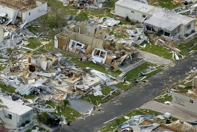
Two tornadoes surveyed by NWS Melbourne struck the U.S. 1 corridor in southern Brevard: an F2 at Barefoot Bay during Tropical Storm Gordon on November 15, 1994, and an EF-0 in Micco on April 16, 2023.
NWS Melbourne's survey index lists the November 15, 1994 Barefoot Bay tornado under Tropical Storm Gordon (NWS Melbourne storm surveys). The office's Gordon summary describes a short-lived F2 tornado that devastated Barefoot Bay as it moved onshore, with one man killed (NWS Melbourne Gordon summary).
The 2023 storm began in the River Groves mobile home community in Micco, moved through the Summit Cove Condominiums complex and then crossed US-1, the survey's spelling, on its way to the Indian River Lagoon. At the Sebastian River Marina and Boatyard on the lagoon side, several boats were moved from their storage rack, and an eyewitness reported a brief waterspout before the circulation ended (NWS Melbourne survey, April 17, 2023).
A third NWS Melbourne survey, of September 13, 2016, followed a rural Grant-Valkaria EF-0 tornado with peak winds of 75 to 85 mph that touched down in St. Sebastian River Preserve State Park and tracked about 3 miles north, from 3 miles southwest to 2 miles northwest of Barefoot Bay (NWS Melbourne survey, September 2016).
Frequently asked questions
When will the Valkaria Road traffic signal on U.S. 1 be built?
FDOT lists the Valkaria Road signal in design with a letting date of August 3, 2027 and an estimated construction cost of $1.3 million. The Town of Grant-Valkaria says a 2023 study recommended it to cut serious crashes and delays for northbound turns.
Was U.S. 1 through Micco and Barefoot Bay repaved?
Yes. FDOT project 435657-1 resurfaced 8.635 miles from the Indian River County line to Goat Creek between Fall 2022 and Spring 2024, and replaced the signals at Micco Road and Barefoot Bay Boulevard. It cost $10.6 million.
Is more paving planned on U.S. 1 in Malabar?
Yes. FDOT is designing a 2.561-mile repaving of the southbound lanes from north of Rocky Point Road to south of Malabar Road, with a letting date of July 7, 2027. The northbound lanes were resurfaced in 2024.
Why is FDOT studying the U.S. 1 shoreline in Palm Bay?
FDOT wants to prevent further erosion from wave action at the base of the slope beside U.S. 1, along the Indian River. FDOT is evaluating long-term stabilization from Hiawatha Avenue to Kingswood Drive in Palm Bay, building on a 2022 feasibility study.
Is U.S. 1 in South Brevard a scenic byway?
Yes. FDOT refers to U.S. 1 through Malabar as the Indian River Lagoon National Scenic Byway on its project page for the northbound resurfacing between Rocky Point Road and Malabar Road.
Sources
- FDOT District 5 (CFLRoads), 435657-1 US 1 from Indian River County Line to north of Goat Creek (Wayback Machine capture; live page 404 on 2026-10-13) https://web.archive.org/web/20251212133957/https://www.cflroads.com/project/435657-1 Used for: completed 8.635 mile resurfacing, Micco Road and Barefoot Bay Boulevard signals, cost, dates, contractor
- FDOT District 5 (CFLRoads), 447092-1 NB US 1 from Rocky Point Rd to Malabar Road (SR 514) (Wayback Machine capture; live page 404 on 2026-10-13) https://web.archive.org/web/20250520000247/https://www.cflroads.com/project/447092-1 Used for: completed northbound resurfacing in Malabar, sidewalk south of Orange Avenue, scenic byway name
- FDOT District 5 (CFLRoads), 452883-1 Southbound U.S. 1 from north of Rocky Point Road to south of S.R. 514 https://www.cflroads.com/project/452883-1 Used for: planned southbound repaving in Malabar, length, costs, letting
- FDOT District 5 (CFLRoads), 454250-1 U.S. 1 at Valkaria Road https://www.cflroads.com/project/454250-1 Used for: planned Valkaria Road signal, costs, letting
- FDOT District 5 (CFLRoads), 454251-1 U.S. 1 at 1st Street Signal https://www.cflroads.com/project/454251-1 Used for: planned 1st Street signal in Grant-Valkaria, costs, letting
- FDOT District 5 (CFLRoads), 456175-1 U.S. 1 Shoreline Stabilization Study https://www.cflroads.com/project/456175-1 Used for: Palm Bay shoreline segment Hiawatha Avenue to Kingswood Drive
- FDOT District 5 (CFLRoads), 448793-1 U.S. 1 (S.R. 5) from Myers Drive to Crane Creek Bridge https://www.cflroads.com/project/448793-1 Used for: Palm Bay and Melbourne resurfacing under construction
- Town of Grant-Valkaria, FDOT U.S. 1 at Valkaria Rd Traffic Signal Installation (news release, July 20, 2026) https://www.grantvalkaria.org/community/page/fdot-us-1-valkaria-rd-traffic-signal-installation Used for: 2023 study, purpose, crosswalk and lighting, Town Hall address
- NWS Melbourne Public Information Statement, damage survey for the April 16, 2023 Micco tornado (IEM AFOS archive) https://mesonet.agron.iastate.edu/cgi-bin/afos/retrieve.py?pil=PNSMLB&sdate=2023-04-17&edate=2023-04-18&fmt=html&limit=5 Used for: tornado crossing US-1 in Micco
- NWS Melbourne, Storm Surveys and Event Summaries index https://www.weather.gov/mlb/surveys Used for: date of the Tropical Storm Gordon Barefoot Bay tornado
- NWS Melbourne, September 13, 2016 Grant-Valkaria tornado survey (PDF), page 2 https://www.weather.gov/media/mlb/surveys/GrantValkariaTornado091316.pdf#page=2 Used for: EF-0 tornado path near Barefoot Bay
- NWS Melbourne, Tropical Storm Gordon 1994 summary (PDF), page 3 https://www.weather.gov/media/mlb/surveys/gordon.pdf#page=3 Used for: F2 tornado at Barefoot Bay
How this page was made
Digital Towns uses AI assistance to research and write its guides, and every page is only as good as the sources it cites. Our goal is the most accurate, useful local information possible.
This page was fact-checked twice before publishing.
If you see an error, or anything you can show is false, tell us right away and we will take a third look.
Report an error
Thank you. We'll take a third look and correct the page if it's wrong.