Short answer: August in South Brevard is hot, humid and stormy. Under NOAA NCEI 1991 to 2020 normals, the Palm Bay cooperative station averages an August high of 91.8 degrees, a low of 72.8 and 7.11 inches of rain, and Melbourne International Airport averages 89.3, 74.7 and 6.67 inches. The airport's August record is 101 degrees, set in 1999, and August 2026 tied 2007 as its fourth warmest August.
Last verified: October 18, 2026, against the sources listed at the end of this page.
How hot is August in South Brevard?
August is the hottest month of the year at the Palm Bay cooperative station, with a 1991 to 2020 normal high of 91.8 degrees, while Melbourne International Airport averages 89.3 degrees by day and 74.7 at night.
Two weather records describe South Brevard. The National Weather Service point forecast for Palm Bay reports current conditions from Melbourne International Airport (KMLB), listed at 28.1 N (NWS Palm Bay forecast), and NOAA NCEI keeps a second long record at cooperative station USC00086761 in Palm Bay. In August the Palm Bay station runs 2.5 degrees hotter in the afternoon than the airport (91.8 minus 89.3) and 1.9 degrees cooler at dawn (74.7 minus 72.8), so every figure on this page names its station (NCEI normals, Palm Bay station).
| Station | Normal high | Normal low | Mean | Rain | Days at 90 F or above |
|---|---|---|---|---|---|
| Melbourne International Airport (KMLB, USW00012838) | 89.3 | 74.7 | 82.0 | 6.67 | 18.2 |
| Palm Bay cooperative station (USC00086761) | 91.8 | 72.8 | 82.3 | 7.11 | 26.2 |
| Vero Beach Regional Airport (USW00012843) | 90.6 | 73.6 | 82.1 | 7.35 | not listed |
Hot afternoons are close to universal. NCEI counts 26.2 August days at 90 degrees or more at the Palm Bay station and 18.2 at KMLB, and the airport averages 30.9 August days at 80 degrees or warmer (NCEI normals, KMLB). The 74.7 degree low at Melbourne International Airport is the warmest monthly normal low in its 1991 to 2020 record, ahead of 73.7 in both July and September.
The month eases only slightly from start to finish. At KMLB the normal high slips from 89.8 degrees on August 1 (NCEI daily normals) to 88.6 on August 31 (NCEI daily normals), while the normal low creeps up from 74.1 to 74.7. The Palm Bay station holds near 91.7 degrees on August 1 (NCEI daily normals, Palm Bay) and 91.2 on August 31, with its low rising from 72.3 to 73.0 (NCEI daily normals, Palm Bay).
For Micco and Barefoot Bay at the south end of the county, the Vero Beach Regional Airport station (USW00012843) in Indian River County gives a third reference point: an August normal high of 90.6 degrees, a low of 73.6 and 7.35 inches of rain (NCEI normals, Vero Beach).
The ocean along the Space Coast offers little cooling in August. The NCEI coastal water temperature guide lists an August average of 83.8 degrees at Trident Pier in Port Canaveral and 83.7 degrees at the buoy 20 nautical miles east of Cape Canaveral (NCEI coastal water temperature guide).
How much rain falls in August in Palm Bay and Melbourne?
August rainfall normals are 7.11 inches at the Palm Bay cooperative station and 6.67 inches at Melbourne International Airport, which ranks August third among the wettest months at both stations, behind June and September.
The average hides a wide spread. At KMLB, one August in four brings less than 4.40 inches and one in four brings more than 7.93 inches, by the NCEI 25th and 75th percentile values for Melbourne International Airport (NCEI normals, KMLB). The airport averages 9.7 August days with at least a tenth of an inch of rain and 1.8 days with an inch or more.
Thunderstorms are the August rain machine. The NWS Melbourne office on Croton Road writes in its station digest that central Florida leads the country in the number of thunderstorm days per year (over 80), and that some relief from summer heat is provided by the afternoon sea breeze or by thunderstorms (NWS Melbourne station digest). At Melbourne International Airport, thunderstorms were reported on 22 days in August 2026 (NWS Melbourne August 2026 climate report).
Tropical systems supply only part of the wet season rain. An NWS Melbourne study of 22 years of data at a north Melbourne rain gauge found that for 1992 to 2013, tropical systems provided 15 percent of the wet season rainfall and about 5 inches per year on average (NWS Melbourne wet season statistics). In a year with a slow-moving storm the share can be far larger, as the 2008 totals near Malabar and Micco below show.
How did August 2026 compare with normal at Melbourne?
August 2026 was hot and dry at Melbourne International Airport: the month averaged 84.2 degrees, 2.2 above normal, and tied August 2007 as the fourth warmest August on the NWS Melbourne list.
NWS Melbourne ranked the month in its August 2026 summary, noting that Melbourne tied August 2007 for its 4th warmest August ever recorded (NWS Melbourne August 2026 summary). The full monthly report for KMLB, issued September 1, 2026, shows the comparison with the 1991 to 2020 normal and with August 2025 (NWS Melbourne climate report, August 2026).
| Measure | August 2026 | Normal | August 2025 |
|---|---|---|---|
| Average high (F) | 92.0 | 89.3 | 90.6 |
| Average low (F) | 76.4 | 74.7 | 76.0 |
| Mean (F) | 84.2 | 82.0 | 83.3 |
| Days at 90 F or above | 25 | 18.2 | 21 |
| Days with 0.10 inch of rain or more | 8 | 9.7 | 15 |
The heat peaked in the third week. NWS Melbourne lists new or tied daily record highs at Melbourne of 97 degrees on August 17, 98 on August 19 (the old record was 96 in 2024), and 95 on both August 23 and August 25 (NWS Melbourne August 2026 records). The 98 degree reading on August 19 was the hottest of the month at the airport.
Rain fell short of normal at Melbourne International Airport. Melbourne collected 4.17 inches, 2.50 inches below its 6.67 inch normal, while Vero Beach to the south of Barefoot Bay recorded 6.68 inches (NWS Melbourne August 2026 rainfall). The wettest day at KMLB was August 26, with 2.67 inches, and the same day brought the strongest gust of the month, 61 mph from 160 degrees.
The whole summer followed the same pattern at Melbourne International Airport. June through August 2026 brought 19.18 inches of rain to Melbourne, 1.09 inches below the 20.27 inch summer normal (NWS Melbourne summer 2026 rainfall), and the summer average of 83.1 degrees ranked seventh warmest, tied with 2023 (NWS Melbourne summer 2026 temperatures).
Which August storms have hit Palm Bay, Malabar, Micco and Barefoot Bay?
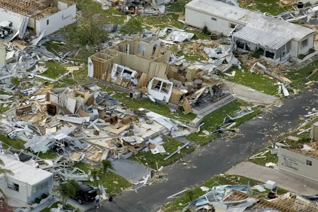
Two August storms stand out in the South Brevard record: Hurricane Erin, which came ashore near Sebastian Inlet in southern Brevard County early on August 2, 1995, and Tropical Storm Fay, which soaked Palm Bay, Malabar and Micco in August 2008.
The NWS Melbourne history of August hazardous weather says Erin made landfall near Sebastian Inlet in southern Brevard County, that Brevard County bore the brunt of the storm, and that wind gusts reached 100 mph between Melbourne Beach and Cocoa Beach (NWS Melbourne August hazardous weather history). On the back side of the storm, heavy rains of up to 8 inches in three hours fell on the afternoon of August 2, and many houses were flooded west and northwest of Melbourne. The NOAA Weather Prediction Center summary places the Erin landfall near Vero Beach instead (NOAA Weather Prediction Center, Erin), so the exact point depends on the agency report.
Fay was a rain event for South Brevard. The NWS Melbourne storm page for Tropical Storm Fay, August 18 to 23, 2008, lists 13.59 inches at the Palm Bay gauge (PLBF1), 17.82 inches at a gauge 2.9 miles north northwest of Malabar, and 16.26 inches at a gauge 4.5 miles northwest of Micco (NWS Melbourne, Tropical Storm Fay). The Malabar and Micco totals are each more than double the 7.11 inch August normal at the Palm Bay station (2 times 7.11 is 14.22 inches).
Fay also brought a tornado to Barefoot Bay. The same NWS Melbourne report records an EF1 tornado at 5:45 p.m. on August 19, 2008, when a tropical rain squall moved onshore and struck the manufactured home community of Barefoot Bay; the tornado damaged 59 residences, and 9 were declared uninhabitable.
August is the start of the busiest stretch of the season for Palm Bay, Grant-Valkaria and the rest of South Brevard. The National Hurricane Center states that the first Atlantic hurricane tends to form in early to mid August, that the peak of the season is September 10, and that most activity occurs between mid August and mid October (National Hurricane Center climatology).
What are the August records at Melbourne International Airport?
The August extremes at Melbourne International Airport are 101 degrees, set on August 2, 1999, and 60 degrees, set on August 7, 1983, in the climate record that the NWS Melbourne monthly report dates from 1939.
The August record high at KMLB sits one degree below the station's all-time high of 102 degrees, set on July 14, 1980, according to the NWS Melbourne station digest for the Melbourne office (NWS Melbourne station digest). The 60 degree August record low at Melbourne International Airport dates from August 7, 1983 (NWS Melbourne climate report, August 2026).
August 2026 came within three degrees of the record. Its highest reading at Melbourne International Airport was 98 degrees on August 19, and its lowest was 72 degrees on August 26, the rainy day that also produced the 61 mph gust. The average relative humidity for the month at KMLB was 75 percent, the figure the NWS Melbourne report gives for August 2026.
Frequently asked questions
What is the average temperature in Palm Bay in August?
The NCEI 1991 to 2020 normals give the Palm Bay cooperative station an August mean of 82.3 degrees, the warmest monthly mean in its record. Melbourne International Airport, the station on the Palm Bay forecast page, averages 82.0 degrees for the month.
Does it rain every day in August in Malabar and Palm Bay?
No. Melbourne International Airport averages 9.7 August days with a tenth of an inch of rain or more, so roughly two days in three stay below that mark. In August 2026 KMLB logged only 8 such days.
How hot was the hottest August day at Melbourne International Airport?
The August record at KMLB is 101 degrees, set on August 2, 1999, according to the NWS Melbourne monthly climate report. The airport's all-time high is 102 degrees, set on July 14, 1980.
Did Tropical Storm Fay cause a tornado in Barefoot Bay?
Yes. NWS Melbourne documented an EF1 tornado that struck the Barefoot Bay manufactured home community at 5:45 p.m. on August 19, 2008, damaging 59 residences and leaving 9 uninhabitable, during the Fay rain bands.
How warm is the Atlantic off Brevard in August?
The NOAA NCEI coastal water temperature guide gives an August average of 83.8 degrees at Trident Pier in Port Canaveral and 83.7 degrees at the Canaveral buoy 20 nautical miles offshore, among the warmest readings of the year at both.
Sources
- NOAA NCEI 1991-2020 monthly normals, Melbourne International Airport (USW00012838) https://www.ncei.noaa.gov/access/services/data/v1?dataset=normals-monthly-1991-2020&stations=USW00012838&format=json&dataTypes=MLY-TAVG-NORMAL,MLY-TMAX-NORMAL,MLY-TMIN-NORMAL,MLY-PRCP-NORMAL,MLY-TMAX-AVGNDS-GRTH090,MLY-TMAX-AVGNDS-GRTH080,MLY-TMIN-AVGNDS-LSTH050,MLY-TMIN-AVGNDS-LSTH040,MLY-TMIN-AVGNDS-LSTH032,MLY-PRCP-AVGNDS-GE010HI,MLY-PRCP-AVGNDS-GE100HI,MLY-PRCP-25PCTL,MLY-PRCP-75PCTL,MLY-TMIN-PRBOCC-LSTH032,MLY-TMIN-PRBOCC-LSTH040 Used for: August highs, lows, rain, threshold days and rainfall percentiles at KMLB
- NOAA NCEI 1991-2020 monthly normals, Palm Bay cooperative station (USC00086761) https://www.ncei.noaa.gov/access/services/data/v1?dataset=normals-monthly-1991-2020&stations=USC00086761&format=json&dataTypes=MLY-TAVG-NORMAL,MLY-TMAX-NORMAL,MLY-TMIN-NORMAL,MLY-PRCP-NORMAL,MLY-TMAX-AVGNDS-GRTH090,MLY-TMAX-AVGNDS-GRTH080,MLY-TMIN-AVGNDS-LSTH050,MLY-TMIN-AVGNDS-LSTH040,MLY-TMIN-AVGNDS-LSTH032,MLY-PRCP-AVGNDS-GE010HI,MLY-PRCP-AVGNDS-GE100HI,MLY-PRCP-25PCTL,MLY-PRCP-75PCTL,MLY-TMIN-PRBOCC-LSTH032,MLY-TMIN-PRBOCC-LSTH040 Used for: August highs, lows, rain and 90 degree days in Palm Bay
- NOAA NCEI 1991-2020 monthly normals, Vero Beach Regional Airport (USW00012843) https://www.ncei.noaa.gov/access/services/data/v1?dataset=normals-monthly-1991-2020&stations=USW00012843&format=json&dataTypes=MLY-TAVG-NORMAL,MLY-TMAX-NORMAL,MLY-TMIN-NORMAL,MLY-PRCP-NORMAL,MLY-TMIN-PRBOCC-LSTH032 Used for: August reference normals south of Micco and Barefoot Bay
- NOAA NCEI 1991-2020 daily normals, KMLB, August 1 https://www.ncei.noaa.gov/access/services/data/v1?dataset=normals-daily-1991-2020&stations=USW00012838&startDate=2010-08-01&endDate=2010-08-31&format=csv&dataTypes=DLY-TMAX-NORMAL,DLY-TMIN-NORMAL#row=2 Used for: August 1 normal high and low at KMLB
- NOAA NCEI 1991-2020 daily normals, KMLB, August 31 https://www.ncei.noaa.gov/access/services/data/v1?dataset=normals-daily-1991-2020&stations=USW00012838&startDate=2010-08-01&endDate=2010-08-31&format=csv&dataTypes=DLY-TMAX-NORMAL,DLY-TMIN-NORMAL#row=32 Used for: August 31 normal high and low at KMLB
- NOAA NCEI 1991-2020 daily normals, Palm Bay station, August 1 https://www.ncei.noaa.gov/access/services/data/v1?dataset=normals-daily-1991-2020&stations=USC00086761&startDate=2010-08-01&endDate=2010-08-31&format=csv&dataTypes=DLY-TMAX-NORMAL,DLY-TMIN-NORMAL#row=2 Used for: August 1 normal high and low in Palm Bay
- NOAA NCEI 1991-2020 daily normals, Palm Bay station, August 31 https://www.ncei.noaa.gov/access/services/data/v1?dataset=normals-daily-1991-2020&stations=USC00086761&startDate=2010-08-01&endDate=2010-08-31&format=csv&dataTypes=DLY-TMAX-NORMAL,DLY-TMIN-NORMAL#row=32 Used for: August 31 normal high and low in Palm Bay
- National Weather Service point forecast, Palm Bay FL https://forecast.weather.gov/MapClick.php?lat=27.9931&lon=-80.6608 Used for: Palm Bay forecast uses Melbourne International Airport (KMLB) observations
- NWS Melbourne climate report for the month of August 2026, Melbourne (CLMMLB, issued September 1, 2026; Iowa Environmental Mesonet NWS text archive) https://mesonet.agron.iastate.edu/cgi-bin/afos/retrieve.py?pil=CLMMLB&sdate=2026-09-01&edate=2026-09-03&fmt=text&limit=1 Used for: August 2026 observations, records, gusts and thunderstorm days at KMLB
- NWS Melbourne, August 2026 and Summer 2026 Weather Summary, page 2 https://www.weather.gov/media/mlb/summary/AugSummer2026.pdf#page=2 Used for: Melbourne August 2026 average and ranking
- NWS Melbourne, August 2026 and Summer 2026 Weather Summary, page 5 https://www.weather.gov/media/mlb/summary/AugSummer2026.pdf#page=5 Used for: Melbourne daily record highs August 2026
- NWS Melbourne, August 2026 and Summer 2026 Weather Summary, page 8 https://www.weather.gov/media/mlb/summary/AugSummer2026.pdf#page=8 Used for: Melbourne and Vero Beach August 2026 rainfall
- NWS Melbourne, August 2026 and Summer 2026 Weather Summary, page 14 https://www.weather.gov/media/mlb/summary/AugSummer2026.pdf#page=14 Used for: Summer 2026 rainfall at Melbourne
- NWS Melbourne, August 2026 and Summer 2026 Weather Summary, page 11 https://www.weather.gov/media/mlb/summary/AugSummer2026.pdf#page=11 Used for: Summer 2026 temperature ranking at Melbourne
- NWS Melbourne, Florida Hazardous Weather Events in August, page 2 https://www.weather.gov/media/mlb/whirl/FloridaHazardousWeather_Aug.pdf#page=2 Used for: Hurricane Erin 1995 in southern Brevard County
- NWS Melbourne, Tropical Storm Fay, August 18-23, 2008 https://www.weather.gov/mlb/fay Used for: Fay rainfall at Palm Bay, Malabar and Micco gauges; Barefoot Bay EF1 tornado
- NOAA Weather Prediction Center, Hurricane Erin, August 1-7, 1995 https://www.wpc.ncep.noaa.gov/tropical/rain/erin1995.html Used for: Erin landfall near Vero Beach (WPC wording)
- National Hurricane Center, Tropical Cyclone Climatology https://www.nhc.noaa.gov/climo/ Used for: Atlantic season timing: first hurricane, September 10 peak
- NWS Melbourne, Some Wet Season Statistics from North Melbourne, Florida https://www.weather.gov/mlb/wet_stats Used for: tropical share of wet season rainfall
- NWS Melbourne Station Digest https://www.weather.gov/mlb/station_digest Used for: thunderstorm days, sea breeze, all-time high
- NOAA NCEI Coastal Water Temperature Guide, all stations table https://www.ncei.noaa.gov/access/coastal-water-temperature-guide/all_table.html Used for: August water temperatures at Trident Pier and the Canaveral buoy
How this page was made
Digital Towns uses AI assistance to research and write its guides, and every page is only as good as the sources it cites. Our goal is the most accurate, useful local information possible.
This page was fact-checked twice before publishing.
If you see an error, or anything you can show is false, tell us right away and we will take a third look.
Report an error
Thank you. We'll take a third look and correct the page if it's wrong.