Short answer: September is the wettest month of the year in South Brevard and the peak of hurricane season. NWS Melbourne monthly climate reports give Melbourne International Airport, whose observations appear on the Palm Bay forecast, a 1991 to 2020 September normal of 7.63 inches of rain, a high of 87.6 degrees and a low of 73.7. The National Hurricane Center places the season peak on September 10.
Last verified: October 18, 2026, against the sources listed at the end of this page.
What are normal September temperatures in Palm Bay and Melbourne?
A typical September afternoon at Melbourne International Airport reaches 87.6 degrees and a typical night falls to 73.7, under the 1991 to 2020 normals printed in the NWS Melbourne monthly climate report (NWS Melbourne climate report, September 2026).
Those airport readings are the ones residents of Palm Bay, Malabar and Grant-Valkaria see on the National Weather Service point forecast for Palm Bay, which lists its current conditions at KMLB, Melbourne International Airport (NWS Palm Bay forecast). Every normal and record on this page is for that airport station.
| September item at KMLB | Value |
|---|---|
| Normal afternoon high | 87.6 F |
| Normal overnight low | 73.7 F |
| Normal monthly mean | 80.6 F |
| Normal days of 90 F or more | 7.8 |
| Normal rainfall | 7.63 inches |
| Normal days with measurable rain (0.01 inch) | 14.5 |
| Record high | 98 F, September 1, 1972 |
| Record low | 57 F, September 21, 1938 |
| Wettest September | 20.94 inches, 2017 |
| Driest September | 1.62 inches, 2002 |
The heat is easing but not gone. KMLB averages 7.8 September days of 90 degrees or more, down from 11.5 in June (NWS Melbourne climate report, June 2026), and the NWS Melbourne station digest counts 63 days a year in the 90s, eased at times by the afternoon sea breeze or thunderstorms (NWS Melbourne station digest).
One detail in the official record is worth knowing. The KMLB report states a climate record period of 1939 to 2026, yet it lists the September record low of 57 degrees for September 21, 1938, a date before that period begins (NWS Melbourne climate report, September 2026). The record high, 98 degrees on September 1, 1972, sits inside it.
Is September the wettest month in South Brevard?
Yes: the 1991 to 2020 September normal at Melbourne International Airport of 7.63 inches is the highest of any month in the NWS Melbourne monthly climate reports, ahead of June at 7.10 inches.
| Month | Normal rain | Report |
|---|---|---|
| January | 2.63 | KMLB report, January 2026 |
| February | 1.98 | KMLB report, February 2026 |
| March | 2.69 | KMLB report, March 2026 |
| April | 2.29 | KMLB report, April 2026 |
| May | 3.53 | KMLB report, May 2026 |
| June | 7.10 | KMLB report, June 2026 |
| July | 6.50 | KMLB report, July 2026 |
| August | 6.67 | KMLB report, August 2026 |
| September | 7.63 | KMLB report, September 2026 |
| October | 4.86 | KMLB report, October 2025 |
| November | 2.55 | KMLB report, November 2025 |
| December | 2.36 | KMLB report, December 2025 |
The margin over June is about half an inch (7.63 minus 7.10 is 0.53), and July and August both fall below either month, at 6.50 and 6.67 inches. After September the normal drops by more than a third, to 4.86 inches in October.
Single Septembers swing far from that average. The wettest September in the KMLB record brought 20.94 inches, in 2017, and the driest 1.62 inches, in 2002 (NWS Melbourne climate report, September 2026).
Rain days stay as frequent as midsummer. An average September at KMLB has 14.5 days with measurable rain, 9.1 with a tenth of an inch or more, 4.4 with half an inch and 2.1 with an inch or more, against 14.4 measurable rain days in July (KMLB report, July 2026) and 15.0 in August (KMLB report, August 2026).
Why is September the peak of hurricane season for Palm Bay, Micco and Barefoot Bay?
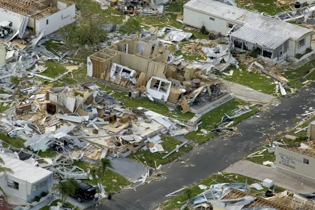
September holds the climatological peak of the Atlantic hurricane season, September 10, in the National Hurricane Center climatology, which covers the whole Atlantic basin off Palm Bay, Micco and Barefoot Bay.
The same climatology says most activity occurs between mid August and mid October, and that the first major hurricane of an average season forms in late August or early September (National Hurricane Center climatology). Its 1991 to 2020 average season has 14 named storms, 7 hurricanes and 3 major hurricanes across the whole basin, not only near Malabar and Grant-Valkaria. The NHC table of an average season reaches its first major hurricane on September 1, its eighth named storm on September 9 and its tenth on September 22. The count climbs from 6 named storms on August 29 to 11 on October 2.
The NWS Melbourne station digest puts it more briefly for the office that serves Palm Bay: tropical cyclones are a nearly annual threat to Florida, and the season peaks in September (NWS Melbourne station digest). The same digest gives the Croton Road office warning responsibility for 10 East-Central Florida counties and the adjacent Atlantic coastal waters out to 60 nautical miles.
Offshore water is at its warmest of the year in September at the Canaveral station 20 nautical miles east of Cape Canaveral, where the NCEI coastal water table lists an average of 84.0 degrees, just above the August figure of 83.7 (NCEI coastal water temperature guide).
Named storms that actually reached Palm Bay, Malabar, Micco and Barefoot Bay, with dates and damage, are listed separately at /florida/south-brevard/disasters/hurricane-history/.
Does lightning ease in September around Palm Bay?
Lightning over the county that includes Palm Bay falls by almost two thirds in September, from about 6,676 strikes in August to about 2,461, in the strike counts NWS Melbourne publishes for Brevard County.
The drop works out to 4,215 fewer strikes (6,676 minus 2,461), or about 63 percent (NWS Melbourne lightning facts and figures). The NWS Melbourne lightning climatology attributes the September decrease to frontal systems over the southeastern United States, a shift in the average wind flow from the southeast to the northeast as high pressure builds in from the north, and decreasing insolation (NWS Melbourne Florida lightning climatology). Melbourne International Airport still logged thunderstorms on 14 days in September 2026 (NWS Melbourne climate report, September 2026).
One September case in the NWS Melbourne record comes from Palm Bay itself. On September 24, 1994, lightning hit a large vendor's tent in Palm Bay, injuring seven of the 150 people inside, and a 40 mph gust blew the tent down a few minutes later, as logged in the NWS Melbourne September hazardous weather history (NWS Melbourne September hazardous weather history).
How did September 2026 compare with normal at Melbourne?
September 2026 at Melbourne International Airport ran close to normal: the average high matched the 87.6 degree normal exactly, nights ran 0.6 degrees warm, and rain fell short at 6.57 inches against 7.63.
| KMLB item | Sept. 2026 | 30 year normal | Sept. 2025 |
|---|---|---|---|
| Mean daily maximum | 87.6 | 87.6 | 86.9 |
| Mean daily minimum | 74.3 | 73.7 | 74.7 |
| Monthly mean temperature | 80.9 | 80.6 | 80.8 |
| 90 degree days | 6 | 7.8 | 1 |
| Rain days of 0.10 inch | 10 | 9.1 | 12 |
| Rain days of 0.50 inch | 6 | 4.4 | 6 |
Those values are the official KMLB numbers (NWS Melbourne climate report, September 2026). The office's month summary gives Melbourne an average of 81.0 degrees, 0.4 above normal, with Vero Beach, south of Barefoot Bay, at 80.8, 0.1 below (NWS Melbourne September 2026 temperature statistics). The two NWS products differ by a tenth of a degree for Melbourne, 80.9 in the monthly report and 81.0 in the summary.
The hottest day came early. Melbourne matched its daily record high for September 5, 96 degrees, last set in 1999, in the NWS Melbourne record table (NWS Melbourne September 2026 records), and the KMLB report shows its top September gust that same day, 45 mph out of 340 degrees (NWS Melbourne climate report, September 2026).
A late month cool front gave a first taste of fall. NWS Melbourne wrote that it brought several days of below normal temperatures and a few record lows tied or broken from the 26th to the 28th (NWS Melbourne September 2026 temperature summary). Melbourne International Airport bottomed out at 64 degrees on September 27, and Vero Beach set a record low of 63 degrees that morning, breaking 64 from 1956.
Rain was patchy. The NWS Melbourne summary describes scattered storms most days, with a brief mostly dry stretch from the 25th through the 29th behind the front, and totals below normal at most primary climate sites (NWS Melbourne September 2026 rainfall summary). Melbourne finished 1.06 inches short with 6.57 inches, and Vero Beach 0.41 short with 6.63 (NWS Melbourne September 2026 rainfall table).
Last verified: October 18, 2026, against NWS Melbourne and NCEI data.
Frequently asked questions
Which month brings Palm Bay the most rain?
September. At Melbourne International Airport, the station the Palm Bay forecast uses, the 1991 to 2020 September normal is 7.63 inches, the highest of any month in the NWS Melbourne climate reports. June is next at 7.10 inches.
When is the peak of hurricane season for South Brevard?
The National Hurricane Center puts the peak of the Atlantic season on September 10, with most activity between mid August and mid October. The NWS Melbourne station digest also says the season peaks in September.
Is it still hot in Palm Bay in September?
Yes. Melbourne International Airport, which supplies the Palm Bay forecast observations, has a September normal high of 87.6 degrees and averages 7.8 days of 90 or hotter, down from 11.5 in June, by the NWS Melbourne monthly climate reports.
What is the September record high at Melbourne International Airport?
The KMLB September record is 98 degrees, set on September 1, 1972, according to the NWS Melbourne monthly climate report. In September 2026 the highest reading was 96 degrees, on September 5.
What was the wettest September on record at Melbourne?
The KMLB record for September is 20.94 inches, in 2017, and the driest September brought 1.62 inches, in 2002, according to the NWS Melbourne climate report for September 2026.
Sources
- National Weather Service point forecast, Palm Bay FL https://forecast.weather.gov/MapClick.php?lat=27.9931&lon=-80.6608 Used for: Palm Bay forecast reports conditions from Melbourne International Airport (KMLB)
- NWS Melbourne climate report for the month of September 2026 (CLMMLB, issued October 1, 2026; Iowa Environmental Mesonet NWS text archive) https://mesonet.agron.iastate.edu/cgi-bin/afos/retrieve.py?pil=CLMMLB&sdate=2026-10-01&edate=2026-10-03&fmt=html&limit=1 Used for: September 1991-2020 normals, records, 2026 observations, gust and thunderstorm days at KMLB
- NWS Melbourne, September 2026 Weather Summary, page 2 https://www.weather.gov/media/mlb/summary/Sep2026.pdf#page=2 Used for: Late month cool front and record lows
- NWS Melbourne, September 2026 Weather Summary, page 3 https://www.weather.gov/media/mlb/summary/Sep2026.pdf#page=3 Used for: Melbourne and Vero Beach September 2026 average temperature
- NWS Melbourne, September 2026 Weather Summary, page 5 https://www.weather.gov/media/mlb/summary/Sep2026.pdf#page=5 Used for: Melbourne and Vero Beach September 2026 temperature records
- NWS Melbourne, September 2026 Weather Summary, page 6 https://www.weather.gov/media/mlb/summary/Sep2026.pdf#page=6 Used for: September 2026 rainfall pattern
- NWS Melbourne, September 2026 Weather Summary, page 8 https://www.weather.gov/media/mlb/summary/Sep2026.pdf#page=8 Used for: Melbourne and Vero Beach September 2026 rainfall against normal
- National Hurricane Center, Tropical Cyclone Climatology https://www.nhc.noaa.gov/climo/ Used for: September 10 peak, mid-August to mid-October activity, first major hurricane timing, average season
- NWS Melbourne, Station Digest https://www.weather.gov/mlb/station_digest Used for: Tropical cyclones a nearly annual threat; season peaks in September
- NWS Melbourne, Monthly Florida Lightning Climatology https://www.weather.gov/mlb/fl_lightning_climo Used for: Why lightning decreases in September
- NWS Melbourne, Lightning Facts and Figures https://www.weather.gov/mlb/lightning_stats Used for: Approximate Brevard County lightning strikes in August and September
- NWS Melbourne, Florida Hazardous Weather by Day, September, page 9 https://www.weather.gov/media/mlb/whirl/FloridaHazardousWeather_Sep.pdf#page=9 Used for: September 24, 1994 lightning strike on a vendor tent in Palm Bay
- NOAA NCEI Coastal Water Temperature Guide, all stations table https://www.ncei.noaa.gov/access/coastal-water-temperature-guide/all_table.html Used for: September average water temperature at the Canaveral buoy
- NWS Melbourne climate report for January 2026 (CLMMLB; Iowa Environmental Mesonet NWS text archive) https://mesonet.agron.iastate.edu/cgi-bin/afos/retrieve.py?pil=CLMMLB&sdate=2026-02-01&edate=2026-02-03&fmt=html&limit=1 Used for: KMLB 1991-2020 normal rainfall for January
- NWS Melbourne climate report for February 2026 (CLMMLB; Iowa Environmental Mesonet NWS text archive) https://mesonet.agron.iastate.edu/cgi-bin/afos/retrieve.py?pil=CLMMLB&sdate=2026-03-01&edate=2026-03-03&fmt=html&limit=1 Used for: KMLB 1991-2020 normal rainfall for February
- NWS Melbourne climate report for March 2026 (CLMMLB; Iowa Environmental Mesonet NWS text archive) https://mesonet.agron.iastate.edu/cgi-bin/afos/retrieve.py?pil=CLMMLB&sdate=2026-04-01&edate=2026-04-03&fmt=html&limit=1 Used for: KMLB 1991-2020 normal rainfall for March
- NWS Melbourne climate report for April 2026 (CLMMLB; Iowa Environmental Mesonet NWS text archive) https://mesonet.agron.iastate.edu/cgi-bin/afos/retrieve.py?pil=CLMMLB&sdate=2026-05-01&edate=2026-05-03&fmt=html&limit=1 Used for: KMLB 1991-2020 normal rainfall for April
- NWS Melbourne climate report for May 2026 (CLMMLB; Iowa Environmental Mesonet NWS text archive) https://mesonet.agron.iastate.edu/cgi-bin/afos/retrieve.py?pil=CLMMLB&sdate=2026-06-01&edate=2026-06-03&fmt=html&limit=1 Used for: KMLB 1991-2020 normal rainfall for May
- NWS Melbourne climate report for June 2026 (CLMMLB; Iowa Environmental Mesonet NWS text archive) https://mesonet.agron.iastate.edu/cgi-bin/afos/retrieve.py?pil=CLMMLB&sdate=2026-07-01&edate=2026-07-03&fmt=html&limit=1 Used for: KMLB 1991-2020 normal rainfall for June and days of 90 F or more
- NWS Melbourne climate report for July 2026 (CLMMLB; Iowa Environmental Mesonet NWS text archive) https://mesonet.agron.iastate.edu/cgi-bin/afos/retrieve.py?pil=CLMMLB&sdate=2026-08-01&edate=2026-08-03&fmt=html&limit=1 Used for: KMLB 1991-2020 normal rainfall for July and measurable rain days
- NWS Melbourne climate report for August 2026 (CLMMLB; Iowa Environmental Mesonet NWS text archive) https://mesonet.agron.iastate.edu/cgi-bin/afos/retrieve.py?pil=CLMMLB&sdate=2026-09-01&edate=2026-09-03&fmt=html&limit=1 Used for: KMLB 1991-2020 normal rainfall for August and measurable rain days
- NWS Melbourne climate report for October 2025 (CLMMLB; Iowa Environmental Mesonet NWS text archive) https://mesonet.agron.iastate.edu/cgi-bin/afos/retrieve.py?pil=CLMMLB&sdate=2025-11-01&edate=2025-11-03&fmt=html&limit=1 Used for: KMLB 1991-2020 normal rainfall for October
- NWS Melbourne climate report for November 2025 (CLMMLB; Iowa Environmental Mesonet NWS text archive) https://mesonet.agron.iastate.edu/cgi-bin/afos/retrieve.py?pil=CLMMLB&sdate=2025-12-01&edate=2025-12-03&fmt=html&limit=1 Used for: KMLB 1991-2020 normal rainfall for November
- NWS Melbourne climate report for December 2025 (CLMMLB; Iowa Environmental Mesonet NWS text archive) https://mesonet.agron.iastate.edu/cgi-bin/afos/retrieve.py?pil=CLMMLB&sdate=2026-01-01&edate=2026-01-03&fmt=html&limit=1 Used for: KMLB 1991-2020 normal rainfall for December
How this page was made
Digital Towns uses AI assistance to research and write its guides, and every page is only as good as the sources it cites. Our goal is the most accurate, useful local information possible.
This page was fact-checked twice before publishing.
If you see an error, or anything you can show is false, tell us right away and we will take a third look.
Report an error
Thank you. We'll take a third look and correct the page if it's wrong.