Short answer: Fort Pierce Inlet State Park is a 713.60 acre state park on the north side of Ft. Pierce Inlet in St. Lucie County. Its Atlantic beach is used for surfing, the man-made north jetty for fishing, Tucker Cove for paddling, and Jack Island for a 6 mile trail on impoundment dikes. The park plan calls these grounds the World War II birthplace of the U.S. Navy Frogmen.
Last verified: October 22, 2026, against the sources listed at the end of this page.
What is Fort Pierce Inlet State Park, and where is it?
Fort Pierce Inlet State Park is a 713.60 acre Florida state park on the north side of Ft. Pierce Inlet in St. Lucie County, with Atlantic beach, the north jetty, Tucker Cove and Jack Island inside its boundary.
The Florida Department of Environmental Protection's approved unit management plan, dated December 2021, says the park was initially acquired on August 10, 1973 with funds from the Environmentally Endangered Lands (EEL) program, and that on March 4, 1974 the Board of Trustees of the Internal Improvement Trust Fund leased the land (Lease Number 2742) to the Division of Recreation and Parks (Fort Pierce Inlet State Park unit management plan, 2021). The same plan sets the park in the middle of a highly urbanized area of St. Lucie County and on the north side of an inlet stabilized with a jetty by the Army Corps of Engineers. Last verified: October 22, 2026, by re-reading the 2021 park management plan, the 2022 Ft. Pierce Inlet management plan and the St. Lucie County shore protection page.
The Hutchinson Island beaches guide covers the St. Lucie County beach parks farther south on the island, and the Pepper Park guide covers the county beach park to the north.
What can visitors do at the Fort Pierce Inlet beach and jetty?
The Atlantic side of Fort Pierce Inlet State Park offers surfing along its Atlantic beach, fishing from the man-made north jetty, and a beach area with bathhouses, pavilions and 261 paved parking spaces.
The 2021 plan's introduction describes visitors surfing along the nearly half mile Atlantic Ocean coastline and fishing along the park's man-made jetty, while another passage of the plan credits the park with nearly a mile of ocean front along the Atlantic (Fort Pierce Inlet State Park unit management plan). Its facility inventory for the Atlantic Beach Access lists two large and two small picnic pavilions, scattered picnic tables, four crushed shell walkways, two bathhouses, outdoor showers, interpretive panels and paved parking for 261 cars. The plan also records that wood beach access boardwalks were replaced with on-grade shell walkways since the 2006 plan.
The inlet plan records sand building up on the park's side of the inlet. To the north of the inlet for at least a mile, accretion of the shoreline took place as the north jetty created an impoundment of beach sand, while to the south of the inlet erosion has prevailed (Ft. Pierce Inlet Management Plan, 2022). The park plan makes the same point from the park's side: because sand along this coast moves south, the park's beaches on the north side of the inlet are slowly deposited with water borne sediments (2021 park plan).
What is at the Inlet Picnic Area, Dynamite Point and Tucker Cove?
The Inlet Picnic Area at Dynamite Point holds the park's playground, five picnic pavilions and an event field, while Tucker Cove on the lagoon side has a paddling launch and a small group area.
The 2021 Fort Pierce Inlet State Park plan lists the Inlet Picnic Area with one large, two medium and two small picnic pavilions, scattered picnic tables and grills, a playground, a restroom with outdoor showers, 50 paved parking spaces and an event field (Fort Pierce Inlet State Park unit management plan). The plan names Dynamite Point, on the western end of the inlet, for the Navy Underwater Demolition Team that trained there to explode ammunition, and records renovated restrooms at the Inlet Picnic Area (Dynamite Point).
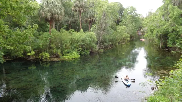
Tucker Cove is the quiet water. The plan's Tucker Cove concession area has a small picnic pavilion, a paddling launch, scattered picnic tables, a composting restroom, a fire ring and an outdoor shower, and since the 2006 plan a motor exclusion zone has been delineated for Tucker Cove (2021 park plan). Johnson's seagrass, an imperiled species, is documented at Fort Pierce Inlet State Park primarily within Tucker Cove. Looking ahead, the plan proposes turning the underused group camp on the east shore of Tucker Cove into an overnight area with options such as glamping, tents or raised platforms, and states that RV campgrounds or cabins will not be considered at this time.
| Use area | Facilities the plan lists | Source |
|---|---|---|
| Atlantic Beach Access | 2 large and 2 small pavilions, 4 crushed shell walkways, 2 bathhouses, outdoor showers, 261 paved parking spots | 2021 plan |
| Inlet Picnic Area (Dynamite Point) | 1 large, 2 medium and 2 small pavilions, grills, playground, restroom and showers, 50 paved spots, event field | 2021 plan |
| Jack Island | Observation deck, interpretive kiosk, foot bridge, paved parking | 2021 plan |
| Tucker Cove concession area | Small pavilion, paddling launch, composting restroom, fire ring, outdoor shower | 2021 plan |
| Trails | Jack Island Shared-Use 6 miles; Coastal Hammock Nature Trail 0.5 miles; paved shared use trail 1.2 miles | 2021 plan |
What is Jack Island, and how long are the trails at Fort Pierce Inlet State Park?
Jack Island is the park's lagoon side preserve of diked mosquito impoundments, reached by a footbridge, with a 6 mile shared use trail on the dikes and an observation structure.
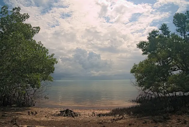
The 2021 plan explains that Jack Island consists primarily of mosquito impoundments created by the construction of dikes around a tidal mangrove estuarine area in the Indian River (Fort Pierce Inlet State Park unit management plan). A small parking area and footbridge provide access to miles of hiking and off-road biking trails along the dikes of Jack Island, and the facility table counts the Jack Island Shared-Use trail at 6 miles. The plan describes an observation tower on Jack Island in one section and lists an observation deck in its facility table. Recent work recorded in the plan includes a new bridge to Jack Island and a repaved parking lot for Jack Island access.
Mangrove swamp is the largest natural community in Fort Pierce Inlet State Park at 491.0 acres in the plan's table, and the park's two other trails are the Coastal Hammock Nature Trail at 0.5 miles and a paved bicycle and pedestrian path that spans 1.2 miles from the park's southern boundary north to its northern boundary (2021 park plan). Offshore, the National Register nomination for the Urca de Lima, the 1715 fleet wreck that became Florida's first underwater archaeological preserve, locates the wreck 200 yards offshore of Jack Island Park, north of Ft. Pierce Inlet (Urca de Lima National Register nomination); the Pepper Park guide covers how to reach it.
Why is Fort Pierce Inlet called the birthplace of the Navy Frogmen?
During World War II the grounds of Fort Pierce Inlet were training grounds for thousands of U.S. Navy Frogmen, whom the state park plan calls the forerunners of today's Navy Seals.
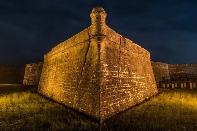
The 2021 Fort Pierce Inlet State Park plan states that the park and adjacent waters were the birthplace and training grounds for U.S. Navy Frogmen, and that the park preserves sites that proved very important for the war effort (Fort Pierce Inlet State Park unit management plan). Dynamite Point, on the western end of the inlet, takes its name from that training. An archaeological survey of the park was completed in 2013, and during the plan's public review a speaker encouraged more interpretive panels on Navy Frogmen history, with park staff naming the half mile coastal hammock trail and the beach dune as possible locations for future interpretive programs.
The St. Lucie County beaches south of the inlet and Avalon State Park are covered in the Hutchinson Island beaches guide.
How was Fort Pierce Inlet built, and why is sand moved south of it?
Fort Pierce Inlet was cut by a local inlet district in 1921 and became a federal project in 1938, and its jetties hold sand on the state park side that beaches south of the inlet lose.
The DEP Ft. Pierce Inlet Management Plan of May 2022 records that the Ft. Pierce Inlet District was established in 1918 by the Florida Legislature as a special taxing district comprising most of St. Lucie County, that dredging began in 1920, and that the final barrier cut was made on May 8, 1921 (Ft. Pierce Inlet Management Plan). The first channel was four feet deep and 100 feet wide, protected by native coquina rock jetties 400 feet long and spaced 900 feet apart. Between 1926 and 1927 the district extended the jetties to 1,800 feet on the north and 1,200 on the south. The Rivers and Harbors Act of August 30, 1935 made the channels and jetties a federal responsibility, and the U.S. Army Corps of Engineers completed the federal project in 1938.
Moving sand past Fort Pierce Inlet is now state policy. Florida Statute 161.142 says inlets interrupt the natural drift of beach-quality sand and directs each level of government to maximize inlet sand bypassing so that sand reaches adjacent eroding beaches (Florida Statutes 161.142). The 2022 inlet plan notes that the St. Lucie County Erosion District was created by special act of the Legislature in 1967, and it sets an initial target bypassing quantity of 140,000 cubic yards per year to the south (Ft. Pierce Inlet Management Plan).
St. Lucie County reports that the U.S. Army Corps of Engineers, Jacksonville District, with the St. Lucie County Erosion District, completed beach renourishment at Fort Pierce on May 18, 2026, placing approximately 400,000 cubic yards of sand on approximately 1.0 miles of shoreline immediately south of Fort Pierce Inlet, offloaded from inside the south jetty (St. Lucie County Fort Pierce Shore Protection Project page). The county page says the federal project was first built in 1971 with 14 periodic and emergency renourishments since 1980, and that questions go to the county's Port, Inlet and Beaches Department at 772-462-6735. During that work the City of Fort Pierce closed the South Jetty Walkway and Beach Access, south of the jetty at Fort Pierce Jetty Park, from March 21 through March 27, 2026 (City of Fort Pierce Jetty Park closure notice).
What rules protect the water around Fort Pierce Inlet State Park?
All waters inside Fort Pierce Inlet State Park are designated Outstanding Florida Waters, and the park borders the Indian River-Vero Beach to Fort Pierce Aquatic Preserve, where damaging seagrass can bring a fine.
The 2021 plan states that all waters within the park are Outstanding Florida Waters under Chapter 62-302 of the Florida Administrative Code, that surface waters are also Class III, and that the park is adjacent to the Indian River-Vero Beach to Fort Pierce Aquatic Preserve designated under the Florida Aquatic Preserve Act of 1975 (Fort Pierce Inlet State Park unit management plan). The DEP page for that preserve lists Indian River and St. Lucie counties, an establishment year of 1969 and 11,000 acres of shallow estuary, barrier island and spoil islands (DEP Indian River-Vero Beach to Fort Pierce Aquatic Preserve page).
For boaters and paddlers leaving the Tucker Cove launch, the aquatic preserve page asks people to avoid shallow waters and raise the motor over seagrass, warns that damage to seagrass can result in a fine up to $1,000, and gives the Florida Fish and Wildlife Conservation Commission line, 1-888-404-FWCC (3922), for injured animals in the Fort Pierce stretch of the lagoon (DEP aquatic preserve page). Those rules sit alongside the Tucker Cove motor exclusion zone recorded in the park plan.
Frequently asked questions
How big is Fort Pierce Inlet State Park?
The 2021 FDEP unit management plan gives Fort Pierce Inlet State Park as 713.60 acres, first acquired on August 10, 1973 through the Environmentally Endangered Lands program.
Can people fish from the jetty at Fort Pierce Inlet State Park?
Yes. The 2021 park plan describes fishing along the park's man-made jetty on the north side of Ft. Pierce Inlet, along with surfing on its Atlantic coastline.
How long is the Jack Island trail?
The 2021 Fort Pierce Inlet State Park plan lists the Jack Island Shared-Use trail at 6 miles along the impoundment dikes, reached by a footbridge from a small parking area.
Why is Fort Pierce Inlet linked to the Navy SEALs?
The state park plan says the park and nearby waters were the World War II birthplace and training grounds of U.S. Navy Frogmen, the forerunners of today's Navy Seals, and Dynamite Point is named for their demolition training.
When was the beach south of Fort Pierce Inlet renourished?
St. Lucie County says the U.S. Army Corps of Engineers and the county Erosion District completed renourishment on May 18, 2026, placing approximately 400,000 cubic yards of sand on about 1.0 miles of shoreline south of the inlet.
Sources
- Fort Pierce Inlet State Park Approved Unit Management Plan, December 2021 (FDEP) https://floridadep.gov/sites/default/files/2021%20Approved%20UMP%20Fort%20Pierce%20Inlet%20State%20Park.pdf Used for: acquisition, acreage, facilities, trails, Frogmen history, Jack Island, Tucker Cove, waters designation
- Ft. Pierce Inlet Management Plan, May 2022 (FDEP) https://floridadep.gov/sites/default/files/Ft.%20Pierce%20Inlet%20Management%20Plan_FINAL%2005-2022_.pdf Used for: inlet history, jetties, federal project, accretion and erosion, bypass target
- National Register nomination, Urca de Lima (National Park Service) https://npgallery.nps.gov/GetAsset/65dde7a3-2344-4969-a70d-73aeccb11666 Used for: wreck location off Jack Island Park
- Indian River-Vero Beach to Fort Pierce Aquatic Preserve (FDEP) https://floridadep.gov/rcp/aquatic-preserve/locations/indian-river-vero-beach-fort-pierce-aquatic-preserve Used for: preserve facts and seagrass fine
- Florida Statutes 161.142 https://www.flsenate.gov/Laws/Statutes/2025/161.142 Used for: inlet sand bypassing policy
- Upcoming Closures at Fort Pierce Jetty Park, March 19, 2026 (City of Fort Pierce) https://www.cityoffortpierce.com/CivicAlerts.aspx?AID=1173 Used for: south jetty walkway closure during renourishment
- Fort Pierce Shore Protection Project (St. Lucie County) https://www.stlucieco.gov/departments-and-services/port-of-fort-pierce/erosion-district/fort-pierce-shore-protection-project Used for: 2026 renourishment, history since 1971, cost shares, department phone
Published by Rytas Dirse, Solo Founder & AI Architect
Built with AI, held to quality gates. US sources, US brands, facts only.
How this page was made
Digital Towns uses AI assistance to research and write its guides, and every page is only as good as the sources it cites. Our goal is the most accurate, useful local information possible.
If you see an error, or anything you can show is false, tell us right away and we will take a third look.
Report an error
Thank you. We'll take a third look and correct the page if it's wrong.