Short answer: The Nassau River-St. Johns River Marshes Aquatic Preserve is a state-protected salt marsh estuary of about 69,000 acres in Duval and Nassau counties, officially designated on November 24, 1969. It lies along the intracoastal waters of the St. Marys, St. Johns and Nassau rivers between Jacksonville and Fernandina Beach, and the Florida Department of Environmental Protection manages it to keep it in essentially natural condition.
Last verified: October 18, 2026, against the sources listed at the end of this page.
What is the Nassau River-St. Johns River Marshes Aquatic Preserve?
It is a state aquatic preserve covering about 69,000 acres of salt marsh estuary in Duval and Nassau counties, between Jacksonville and Fernandina Beach, designated in 1969.
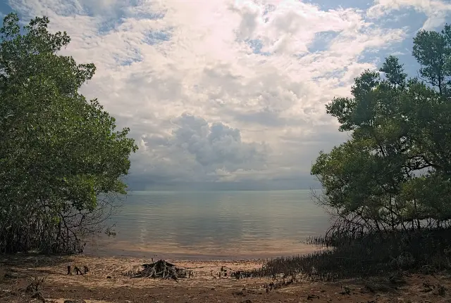
The Florida Department of Environmental Protection says the preserve lies along the Atlantic intracoastal waters of the St. Marys, St. Johns and Nassau rivers on the northeastern coast of Florida. DEP describes it as a vast salt marsh estuary with numerous interconnecting tidal creeks, rivers and channels and some small tree islands, and lists its recreational uses as boating, kayaking, swimming, sunbathing, bird-watching and fishing. DEP's office hours for the preserve are 8 a.m. to 5 p.m.
It has a smaller sister preserve. The Florida Fish and Wildlife Conservation Commission boating guide for Nassau and Duval counties describes both, and the April 1986 joint management plan covers the two together. The plan says the Trustees recognized Fort Clinch as an aesthetic preserve and the Nassau River-St. Johns River Marshes as a biological preserve.
| Item | Nassau River-St. Johns River Marshes | Fort Clinch |
|---|---|---|
| Counties | Duval and Nassau | Nassau, along Amelia Island |
| Designated (FWC) | November 24, 1969 | March 4, 1970 |
| Purpose (FWC) | Protect the Nassau Sound area marshes and associated waters | Aesthetic buffer for the state park and historic Fort Clinch |
| Size, FWC guide | About 69,000 acres | About 7,600 acres |
| Size, 1986 plan | About 57,000 acres | About 9,000 acres of surface water |
The acreage has been counted differently over time, and the agencies do not explain the change. Statewide counts also differ: DEP's Aquatic Preserve Program lists 43 designated preserves covering over 2.9 million acres of submerged lands, while the FWC guide says Florida has 41 aquatic preserves encompassing almost two million acres.
Where are the preserve's boundaries around Jacksonville?
The preserve reaches from State Road 17 in Nassau County south and east to the St. Johns River in Duval County, with a chain of barrier islands on its ocean side.
That description is from the April 1986 management plan prepared for the Florida Department of Natural Resources. It says the preserve extends south from A1A and east from State Road 17 in Nassau County to the St. Johns River in Duval County, and that portions of the Nassau, Amelia and Fort George rivers also lie within its boundaries. The barrier islands, the plan says, include Black Hammock, Fort George, Long and Little Talbot Islands in Duval County and Amelia Island in Nassau County, and some have dune ridges that exceed 30 to 40 feet in elevation.
The plan describes two inlets inside the preserve besides the river mouths: the Nassau River inlet between the southern tip of Amelia Island and the northern tip of Little Talbot Island, and the Fort George inlet between the southern end of Little Talbot Island and Wards Bank, a sand bank separating the Fort George and St. Johns rivers. Both, it said, had shoaling problems and were navigable only by small craft. The plan names the City of Fernandina Beach and the consolidated City of Jacksonville as the bordering governments, with unincorporated communities including Nassauville, Hedges, Amelia City, Franklintown, Mayport and Cedar Point.
The legal line is set in state law. Section 258.39, Florida Statutes declares the Nassau River-St. Johns River Marshes Aquatic Preserve as described in the Official Records of Duval County in Volume 3183, pages 547-552, and in the Official Records of Nassau County in Book 108, pages 232-237.
Why did Florida protect these Jacksonville marshes in 1969?
The 1986 management plan for the Nassau River and St. Johns River marshes says Florida's aquatic preserve system grew out of public concern over dredge and fill activities rampant in the late 1960s.
In 1967, according to the plan, the Florida Legislature passed the Randall Act, Chapter 67-393, Laws of Florida, which set up procedures regulating previously unrestricted dredge and fill on state-owned submerged lands, including the marshes of Duval County. On October 21, 1969, the Governor and Cabinet, sitting as the Trustees of the Internal Improvement Trust Fund, adopted a report of the Interagency Advisory Committee on Submerged Lands Management, and the plan's resolution reaffirms the Trustees' designation of October 21, 1969 for both preserves it covers.
The current agency pages give a different date. DEP says the preserve was officially designated on November 24, 1969, with the primary goal of protecting the estuarine resources of the Nassau Sound area's marshes and associated waters against urban, residential and industrial development. FWC gives the same November date. This guide reports both dates because the sources differ and none of them explains the gap.
The rules that followed are strict. The 1986 plan quotes Chapter 258, Florida Statutes, as directing that state-owned submerged lands within aquatic preserves be set aside forever in their essentially natural or existing condition, and its resolution prohibits drilling oil and gas wells, mining minerals and dredging for the primary purpose of obtaining upland fill inside the preserve. FWC notes that the Aquatic Preserve Act of 1975 brought existing preserves under a standard set of management criteria, and DEP's program page dates the modern era of aquatic preservation to that act. DEP's current conservation objective for the Duval and Nassau marshes keeps the same idea: safeguard the essentially natural condition while minimizing water pollution and the loss of wetlands.
What lives in the salt marsh north of the St. Johns?
DEP's species list for the Duval and Nassau preserve runs from clapper rails and wood storks to bottlenose dolphins, manatees, diamondback terrapins and red drum.
The DEP preserve page groups the animals of the marsh north of the St. Johns River as follows; the table gives a selection from each of its lists.
| Group | Species DEP lists for the preserve |
|---|---|
| Nesting and migrating birds | Clapper rails, willets, red-winged blackbirds, seaside sparrows, marsh wrens, herons, egrets, ibis, wood storks |
| Mammals | Raccoon, marsh rabbit, bobcat, river otter, white tailed deer, bottlenose dolphin, manatee |
| Reptiles | Loggerhead sea turtle, green sea turtle, diamondback terrapin, American alligator |
| Fish | Striped mullet, spotted sea trout, red drum, southern flounder, Florida pompano, sheepshead, among others |
The engine is the grass. DEP says frequent tidal flushing contributes to high primary plant production, that the marshes serve as nurseries for fish and wildlife, and that the tidal creeks are feeding grounds for commercially valuable fish species. The National Park Service says salt marsh makes up about 75 percent of the Timucuan Ecological and Historic Preserve in Jacksonville, with roughly 35,000 acres of salt marsh inside the national preserve. Smooth cordgrass, Spartina alterniflora, is the most common salt marsh grass, according to the NPS; in the high marsh, flooded only by the highest tides, it grows beside black needlerush in a patchy mosaic. The NPS adds that estuaries provide shelter and food for over 75 percent of marine fisheries species, and that viewing Round Marsh with the naval base behind is close to what native people saw around 500 years ago.
Geologically, DEP classes the preserve's barrier islands, marshes and channels as the southernmost extension of the St. Marys Meander Plain, the Sea Islands coast that stretches from the St. Johns River to the Santee River in South Carolina. It notes that the marshes are steadily rising in elevation as sediment builds, while sea level rise works against that growth.
How has the preserve changed since the 1986 plan?
The 1986 plan is a snapshot of the pressures on the north Jacksonville marsh four decades ago, when Fort George Island was still in private hands.
The plan recorded that some 1,602 acres of uplands inside the preserve, mostly tree islands and high marsh, had been bought by the state under the Environmentally Endangered Lands Program and designated the Nassau Valley Marshes State Reserve. It noted that Big and Little Talbot Islands were protected by the state, while Black Hammock and Fort George Islands in Duval County were privately owned.
Fort George Island was the flash point. The plan reported that the Fort George Island Development of Regional Impact proposed a 1,400 unit development, two marinas and more traffic on the Mayport Ferry, with an anticipated loss of about 7.7 acres of salt marsh and associated wetlands. Today the island is home to Fort George Island Cultural State Park, which Florida State Parks describes as a site of human occupation for over 5,000 years, named for a 1736 fort built to defend the southern flank of Georgia when it was a colony.
Water quality was the other worry in 1986. The plan said all formerly approved shellfish harvesting areas in Nassau County had been reclassified as prohibited because of chronically high fecal coliform bacteria levels. In Duval County, it listed open shellfish harvesting areas in parts of Sawpit Creek and the Fort George River and all of Simpson Creek, and Class II waters in parts of the Fort George River, the Intracoastal Waterway and its tributaries, the Nassau River and Creek, and Pumpkinhill Creek. It also counted seven sewage treatment or package plants just south of the Duval boundary on the St. Johns River. Those are 1986 conditions, not current classifications.
How do people get out on the preserve in Jacksonville?
Mostly by boat or kayak from surrounding Jacksonville parks, because DEP says the aquatic preserve itself offers no on-site facilities.
The National Park Service lists the Cedar Point boat ramp into Horseshoe Creek as a free launch for powered and non-powered boats. At Fort George Island Cultural State Park, Florida State Parks says small boats, canoes and kayaks can be launched on the tidal waters behind the Ribault Club, a restored 1920s clubhouse that is now a visitor center. The park lists its hours as 8 a.m. to sunset every day of the year, with no fee required; the Ribault Club is open Wednesday through Sunday, 9 a.m. to 5 p.m., and closed on Thanksgiving and Christmas. The park is one of seven Talbot Islands State Parks, along with Pumpkin Hill Creek Preserve State Park, Amelia Island State Park, Little Talbot Island State Park, Yellow Bluff Fort Historic State Park, Big Talbot Island State Park and George Crady Bridge Fishing Pier State Park.
On the water in the Duval County marshes, DEP tells visitors to follow current FWC saltwater fishing and boating regulations. It says seagrass is protected within aquatic preserves, advises boaters to avoid shallow waters and raise the motor over seagrass, and warns that damage to seagrass can result in a fine of up to $1,000. DEP suggests April through October for getting in the water, when average water temperatures are above 70 degrees, and November through March for fishing and bird-watching.
People used these Jacksonville marshes long before the preserve existed. DEP reports over 100 documented archaeological and historical sites in the coastal region around the preserve, with the earliest traces of human presence dating to about 3500 BC, and says midden excavations show mullet, sheepshead, black drum and catfish were the main fish eaten, with oysters, clams, mussels and whelks. The Timucuan Preserve describes a shared cultural and natural history of over 6,000 years, from the shell middens of the Timucua to the tabby structures of Kingsley Plantation.
Last verified: October 18, 2026, by re-reading DEP's preserve and aquatic preserve program pages, the FWC Nassau and Duval boating guide, the 1986 management plan on GovInfo, section 258.39 of the Florida Statutes, three Timucuan Preserve pages from the National Park Service, and the Fort George Island Cultural State Park page.
Frequently asked questions
When was the Nassau River-St. Johns River Marshes Aquatic Preserve created?
DEP and FWC list the official designation as November 24, 1969. The 1986 management plan instead reaffirms a Trustees designation of October 21, 1969. Both followed the 1967 Randall Act, which first regulated dredge and fill on state-owned submerged lands.
How big is the aquatic preserve north of Jacksonville?
DEP and FWC list about 69,000 acres across Duval and Nassau counties. The 1986 management plan gave approximately 57,000 acres, so the preserve's acreage has been measured differently over the decades.
Is the aquatic preserve the same as the Timucuan Preserve?
No. The aquatic preserve is a state designation over submerged lands managed by DEP, while the Timucuan Ecological and Historic Preserve is a National Park Service unit in Jacksonville with about 35,000 acres of salt marsh.
Where can boats launch into the preserve in Duval County?
The preserve has no facilities of its own. The NPS Cedar Point ramp into Horseshoe Creek is a free launch, and Florida State Parks allows small boats, canoes and kayaks to launch behind the Ribault Club on Fort George Island.
Can boaters be fined for damaging seagrass in the preserve?
Yes. DEP says seagrass is protected within aquatic preserves and that damage to seagrass can result in a fine of up to $1,000, so boaters near Jacksonville are told to avoid shallow water and raise the motor.
Sources
- Nassau River-St. Johns River Marshes Aquatic Preserve, Florida DEP https://floridadep.gov/node/8383 Used for: acreage, 1969 designation, location, species, geology, archaeology, conservation, partners, seagrass fine
- Aquatic Preserves, Boating and Angling Guide to Nassau and Duval Counties (FWC) https://gis.myfwc.com/boating_guides/duval/pages/aquatic_preserves.html Used for: designation date, purpose, 69,000 acres, Fort Clinch comparison
- Nassau River-St. Johns River Marshes and Fort Clinch State Park Aquatic Preserves Management Plan (Florida DNR, April 1986), via GovInfo https://www.govinfo.gov/content/pkg/CZIC-qh90-75-f6-n37-1986/html/CZIC-qh90-75-f6-n37-1986.htm Used for: boundaries, 57,000 acres, barrier islands, inlets, communities, Randall Act, 1969 formal action, Nassau Valley Marshes State Reserve, shellfish areas, Fort George DRI
- Nature, Timucuan Ecological and Historic Preserve (NPS) https://www.nps.gov/timu/learn/nature/index.htm Used for: 6,000 years shared history, Kingsley Plantation tabby
- Salt Marsh, Timucuan Ecological and Historic Preserve (NPS) https://www.nps.gov/timu/learn/nature/saltmarsh.htm Used for: 75 percent salt marsh, cordgrass, needlerush, 35,000 acres, Round Marsh, fisheries nursery
- Water Activities, Timucuan Ecological and Historic Preserve (NPS) https://www.nps.gov/timu/planyourvisit/wateractivities.htm Used for: Cedar Point boat ramp into Horseshoe Creek
- Aquatic Preserves, Florida DEP Office of Resilience and Coastal Protection https://floridadep.gov/rcp/aquatic-preserve Used for: 43 preserves, 2.9 million acres, program purpose
- Section 258.39, Florida Statutes, Boundaries of preserves http://www.leg.state.fl.us/statutes/index.cfm?App_mode=Display_Statute&URL=0200-0299/0258/Sections/0258.39.html Used for: legal description by official records
- Fort George Island Cultural State Park, Florida State Parks https://www.floridastateparks.org/parks-and-trails/fort-george-island-cultural-state-park Used for: 5,000 years of occupation, 1736 fort, Ribault Club launch, Talbot Islands State Parks
How this page was made
Digital Towns uses AI assistance to research and write its guides, and every page is only as good as the sources it cites. Our goal is the most accurate, useful local information possible.
This page was fact-checked twice before publishing.
If you see an error, or anything you can show is false, tell us right away and we will take a third look.
Report an error
Thank you. We'll take a third look and correct the page if it's wrong.